Burkina: "The land of upright people"
BURKINA.com
Tourism, Travel, & Information Guide
to the African Country of Burkina Faso.
|
BURKINA.comTourism, Travel, & Information Guide |
|
|
|
 |
 |
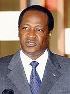
Long time Burkina Faso President Blaise Compaoré |
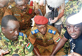
October 31st, 2014 photo of Colonel Issaac Zida commander Presidential guard and Army comander announce ouster of Blaise... Kampala, Uganda |
The current president is Blaise Compaoré, who came to power in 1987 after a coup d'état that killed Thomas Sankara.
BREAKING NEWS, NOVEMBER 2014: NEW PRESIDENT OF
BURKINA
Read
more here: Burkina
Faso Army Backs Presidential Guard Official to Lead Transition
... which assumes a reconsideration of the constitution of June 2,
1991, which established: a semi-presidential government with a parliament
(Assemblée)
which can be dissolved by the President of the Republic, who is elected
for a term of 5 years. The year 2000 saw a constitutional amendment reducing
the presidential term from 7 to 5 years, which was enforced during the
2005 elections.
- The parliament consists of two chambers: the lower house (l'Assemblée Nationale) and the upper house (la Chambre des Représentants).
There is also a constitutional chamber, composed of ten members, and an economic and social council whose roles are purely consultative.
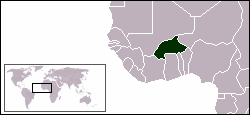
- The administrative divisions of Burkina Faso are divided into 13 regions, 45 provinces, and 301 departments.
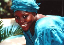
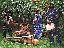 Probably the thing Burkina Faso is most famous for is its music and drumming culture. What a great country to visit if you are interested in learning West African drumming!
As with music, art is also part of the culture of Burkina Faso.
The country hosts the International Arts and Crafts Fair, Ouagadougou, better known by its French name as SIAO, Le Salon International de L'Artisanat de Ouagadougou, one of the most important African handicraft fairs in the world.
Burkina Faso has a primarily tropical climate with two very distinct seasons: the rainy season with between 24-35 inches (600 and 900 mm) of rainfall, and the dry season during which the harmattan blows, a hot dry wind from the Sahara.
The rainy season lasts approximately 4 months, May/ June to September, and is shorter in the north of the country.
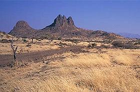 The average altitude is 400 metres (1,300 ft) and the difference between the highest and lowest terrain is no greater than 600 metres (2,000 ft). Burkina Faso is therefore a relatively flat country, with a very few localised exceptions.
Burkina Faso is made up of two major types of countryside:
-The larger part of the country is covered by a peneplain which forms a gently undulating landscape with, in some areas, a few isolated hills, the last vestiges of a precambrian massif.
- The south-west of the country forms a sandstone massif, where the highest peak is found: Ténakourou (749 m, 2,450 ft). The massif is bordered by sheer cliffs up to 150 metres (490 ft.) high.
SEE OUR BURKINA MAPS SECTION
The country owed its former name of Upper Volta to three rivers which cross it: le Mouhoun (formerly called the Black Volta), le Nakambé (the White Volta) and le Nazinon (the Red Volta).
Le Mouhoun, along with la Comoé which flows to the south west, is the country's only river which flows year-round.
The basin of the Niger River also drains 27% of the country's surface. Its tributaries (le Béli, le Gorouol, le Goudébo and le Dargol) are seasonal streams, and only flow for 4 to 6 months a year but can cause large floods.
The country also contains numerous lakes. The principal lakes are Tingrela, Bam and Dem, and the large ponds of Oursi, Béli, Yomboli, and Markoye.
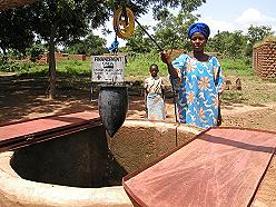
Water shortages are often a problem, especially in the north of the country.
 One of the poorest countries in the world, landlocked Burkina Faso has a high population density, few natural resources, and a fragile soil.
It is ranked as the 28th poorest nation, among other nations such as the Republic of the Congo and Tajikistan, represented numerically in its low GDP per capita income of $1,300.
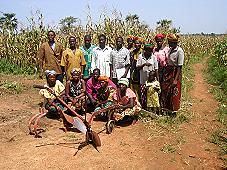
This can be explained by its population growth and its arid soil. About 90% of the population is engaged in (mainly subsistence) agriculture, which is highly vulnerable to variations in rainfall.
Agriculture represents 32% of its gross domestic product and occupies 80% of the working population. It consists mostly of livestock but also, especially in the south and southwest, of growing sorghum, millet, maize (corn), peanuts, rice, and cotton.
Industry remains dominated by unprofitable government-controlled corporations, most specifically in its mineral exploitation of copper, iron, manganese, and, above all, gold. The effects are corruption and financial disparity. (The rich getting richer and the poor getting poorer)
A large part of the economic activity of the country is funded by international aid.
Lack of work causes a high rate of emigration: for example, three million people from Burkina Faso live in Côte d'Ivoire. According to the Central Bank of Western African States (La Banque Centrale des États de l'Afrique de l'Ouest), these migrants send tens of billions of CFA francs back to Burkina Faso each year.
 |
United Nations Square in |
Burkina Faso has an estimated life expectancy at birth of slightly under 50 years of age. The median age of its inhabitants is under 17.
The Population growth rate is 2.71% (2000 est.)
Population estimates take into account the effects of excess mortality due to AIDS; this can result in lower life expectancy, higher infant mortality and death rates, lower population and growth rates, and changes in the distribution of population by age and sex than would otherwise be expected.
The July 2000 estimated 11,946,065 Burkinabè belong to two major West African cultural groups-the Voltaic and the Mande. The Voltaic are far more numerous and include the Mossi, who make up about one-half of the population. Additionally, about 5,000 Europeans live in Burkina Faso.
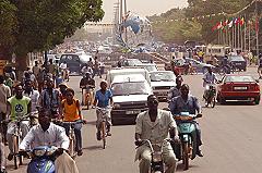
The population is concentrated in the south and center of the country, sometimes exceeding 48 per square kilometer (125/sq.mi). This high population density, causes annual migrations of hundreds of thousands, for seasonal employment.
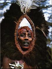
Approximately 50% of the population is Muslim; Christians account for about 30%, and followers of traditional African religions (typically animism of various forms) make up about 20%. Many Christians and Muslims incorporate elements of animism into their religious practices.
 Education in Burkina Faso is structured primary, secondary, and higher education. Education is technically free and officially mandatory until the age of 16, however few Burkinabè have had formal education.
Though schooling is free, attendance is not enforced, and only about 35% of Burkina's primary school-age children receive a basic education. Institutions of higher education include the University of Ouagadougou and The Polytechnical University in Bobo-Dioulasso.
There is also an International School of Ouagadougou, which is an American based private school, which is situated in the capital city, Ouagadougou.
The United Nations Development Program Report places Burkina Faso as the most illiterate country in the world, with only a 12.8% literacy rate.
TRAVELERS: SEE OUR TRAVEL & TOURISM SECTION
Use Ouagadougou as your destination city and compare the travel services.
Check out this Bi- annual Event: The International Arts and Crafts fair in Ouagadougou |
Advertise on this websiteDo you have a business related to Burkina or Africa that
you would like to advertise on this website? Test-king
PMP certification |
Image Copyright NoteBurkina.com is currently seeking royalty free images of the country of Burkina Faso and the people living there for use on our webpages. |

© 2006-2018
Burkina.com. All rights reserved, other than Wikipedia.
Burkina.com is a division of Basecamp International... yet another Net105 Venture. Read our privacy policy here.


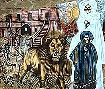 The use of iron, ceramics and polished stone developed between 1500 and 1000 BC, as well as a preoccupation with spiritual matters, as shown by the burial remains which have been discovered.